DRAFT, FOR JP’S REVIEW ONLY
DRONE SERIES, ARTICLE 2 OF 7
Planned rotation date: Sunday, October 18, 2026
SEO title: Drone Real Estate Photography: Sell Faster From the Air
Focus keyphrase: drone real estate photography
Slug: drone-real-estate-photography
Meta description: Show buyers the full story with professional drone real estate photography. Explore aerial photos, video, mapping, licensing, and shoot planning.
Categories: Video Production, Cinematography, Camera Operator, Locations
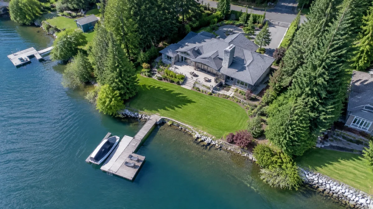
A listing photo can show a home. An aerial image can show how the home fits its land, neighborhood, and surroundings. That extra context matters for waterfront properties, large lots, rural homes, and distinctive locations.
Industry sources have associated aerial imagery with faster sales, including a widely repeated claim of about 68% faster. Some sources also report potential price premiums of up to roughly 10%. These are reported associations, not guaranteed outcomes. Property, market, image quality, and listing strategy all matter.
Drone photography is also becoming more common. National Association of REALTORS® technology surveys report that 35% of respondents used drones in 2024 and 52% in 2025. How can your next listing stand out with imagery that helps buyers understand the whole property?
WHAT AERIAL PHOTOGRAPHY CAN SHOW
For some listings, the strongest image is not a close-up of the front door. It is the view that helps a buyer understand the setting. NAR notes that aerial images can highlight a home’s landscape, outdoor features, and location.
Penny Asked: When you look at a property from above, what can a buyer see that ground-level photos might miss?
Rob: Scale and context. You can show the relationship between the house, the yard, the driveway, and the surrounding area. For a waterfront property, that might mean the shoreline, dock, and how the home sits beside the water. For a rural listing, it could be acreage, outbuildings, access roads, and neighboring land.
Aerials can also show the roof’s visible condition, but they are not a substitute for a professional inspection. And a photo does not establish legal property boundaries. If boundary lines are important to the listing, use verified parcel information and make sure it is represented accurately.
The goal is to give buyers a clearer sense of place. A good “money shot” makes the property’s best feature obvious without implying something the imagery cannot verify.

PHOTO, VIDEO, OR MAPPING?
A steady aerial photograph and a moving drone video tell different stories. Mapping is a separate tool, best suited to projects where the client needs measured visual information, not just a striking listing image.
Penny Asked: How do you decide between a flyover, a fly-through, or a mapping deliverable for a listing?
Rob: Start with what the buyer needs to understand. A flyover can establish the setting and reveal the home’s layout within the lot. A fly-through can create a smoother, more cinematic path around the property. We plan the route carefully and keep safety and airspace limits in mind.
For a land listing or development site, a mapping project may be more useful than a cinematic pass. Photogrammetry can produce 3D models and orthomosaics. With suitable RTK equipment, ground control points, and a professional workflow, results can reach centimeter-level accuracy. But that does not automatically make the output a legal boundary survey. The right deliverable depends on the intended use.
The Mavic 2 Pro is our general-purpose choice for real estate photos and video, inspections, and mapping work. The Inspire 2 is our cinematic workhorse. Its dual-operator mode lets one person fly while another controls the camera, supporting safer, more fluid video capture.

LICENSING, AIRSPACE, AND LIABILITY
Commercial drone work has rules. Hiring a pilot who understands them protects the shoot, the listing, and the people nearby. Spokane Productions lists FAA Part 107-certified pilots and drone liability insurance among its video production services.
Penny Asked: What should a realtor verify before hiring a drone pilot?
Rob: First, confirm the pilot has an active FAA Part 107 Remote Pilot Certificate. I passed the Part 107 test the first day it was offered, and I maintain my certificate through recurrent training every 24 calendar months. Commercial flights also require the aircraft to be registered, Remote ID compliant, and authorized for the airspace where the flight will take place.
The FAA says drones that are registered or required to be registered, including those used for business, must comply with Remote ID. Airspace approval is another important check. Many authorizations come through quickly, but some locations near airports or in busy urban airspace may need 30 to 60 days of lead time. Plan early.
There is also financial risk. The FAA lists civil penalties up to $27,500 for failure to register; penalties depend on the specific violation, so that number is not a blanket penalty for every issue. A realtor or brokerage that commissions unlicensed work could also face liability if an incident occurs. The outcome depends on the circumstances, but a hobbyist may not carry commercial liability insurance. Ask for proof of credentials and insurance, and put responsibilities and image-use terms in writing.

PLANNING A LISTING SHOOT
A smooth shoot starts before the drone leaves the case. The property, light, airspace, and desired deliverables all shape the plan.
Penny Asked: What does a typical shoot look like, and how can an agent make the most of the visit?
Rob: We start with a conversation about what the listing needs. Then we scout, check conditions and airspace, plan the shots, capture the material, and deliver the files. Golden hour can give a home warm, attractive light, but the right time depends on the property and the weather.
A single visit is often enough for a straightforward listing. We can provide stills, edited video, and MLS-ready files, depending on the request. We back up footage in at least three locations and can deliver to a digital imaging technician on set when a production calls for it.
Pricing depends on the property, travel, timing, airspace requirements, and deliverables. The useful comparison is not just the cost of a shoot. It is the value of clear marketing against the carrying costs of a listing that remains unsold. We can scope the work to fit the property and your marketing plan. For broader production needs, see our video production services.
PLAN YOUR LISTING’S AERIAL SHOOT WITH SPOKANE PRODUCTIONS
What should buyers understand about your listing before they ever step through the door? Tell us about the property, timing, and imagery you need. We’ll help plan a practical shoot and recommend the right deliverables.
Contact Spokane Productions or visit our studio at 5380 E Seltice Way, Suite A, Post Falls, Idaho.
We look forward to working with you!

Research and reference links
- NAR: Drones in real estate
- NAR: 2025 REALTOR® Technology Survey
- FAA: Remote Identification of Drones
- FAA: Small Unmanned Aircraft Systems (Part 107)
- Matterport: Using Drone Photography to Boost Home Sales
The requested first-series article, “Professional Drone Services: An Interview with Rob Miller,” was not discoverable as a live page during research, so no unverified URL is included. Add its confirmed internal link before publication.